


产品概述
PROCUCT OVERVIEW林业“一张图”综合智慧信息系统由浩海科技自主研发,并荣获2018年山东名牌产品称号。
林业“一张图”综合智慧信息系统是一套资源配置网络化管理的可离线、数据可更新、使用便捷、标识完整的二维“一张图”电子地理信息网络化管理系统,实现火灾地区地貌植被及周边资源配置的快速展示,给指挥人员提供准确的、网络化的辅助指挥信息。它能配合森林防火应急指挥需要,让指挥人员能够在火灾现场,掌握周边资源配置信息,对防火队伍的部署、指挥、调度进行快速决策,达到迅速控制火势,人员迅速撤离的目的。
林业“一张图”综合智慧信息系统有地图展示、地图操作、地图测量、辅助信息、图层分类、地图输出、资源查询、经纬度定位、战区定位、属性查看、应急预案、辅助绘制等功能
技术参数
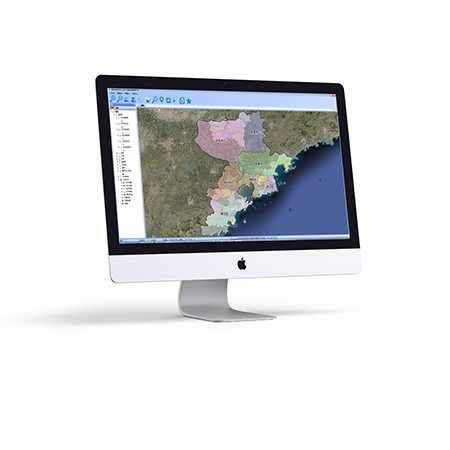
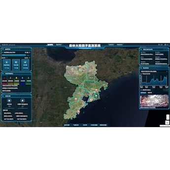
SPECIFICATION1.基于40战区森林防火重点区域划分的地图展示,软件将市林业局划分的40个战区按不同颜色重点显示,让指挥者纵观所有战区地理分布。
2.基于网络化管理的资源配置图层分类展示,将防火资源按照“指挥网”、“路网”、“水网”、“站网”、“阻隔网”、“监控网”六大网络分类展示,进行网络化管理。
3.基于卫星地图的可离线、可更新的资源配置展示, 它采用离线浏览技术,让在线网络地图实现离线本地浏览。让指挥人员在无网络的山区中也可离线浏览新的电子卫星地图和防火要素,进行指挥部署。避免因深入防火前线无图可用,影响扑救作战任务。
4.基于卫星地图的各战区资源配置地图的输出打印, 它提供各比例尺出图功能,将汇集的地图数据,战区简介、战区指挥组成员,打印成纸质地图,供指挥调度使用。
应用示例
APPLICATION EXAMPLESN热销产品
Hot Products
-
智能巡更管理系统
智能巡更管理系统可充当动态监测者角色,具有图片实时上传、拍摄小视频、获取实时天气状况、火情定位与管理、人员定位、人员巡更轨迹的查询与回放的功能特性,可以对巡防人员进行科学化管理,巡防人员可进行物品的申请、请消假等操作,系统对人员的考勤进行统计、分析并形成报表。智能巡更系统支持地图的基本操作、图层管理、数据采集等操作,可以对监控区域资源进行有效管理。
查看详情
智慧管廊综合管理平台
浩海智慧管廊综合管理平台通过先进的云计算、大数据、物联网等计算机技术、网络技术、通信技术和管理技术,将三维地理信息、设备运行信息、环境信息、安全防范信息、视频图像、预警报警信号、管理信息等内容进行融合,形成一个协同作用的管廊运营监控整合平台。
查看详情


青岛浩海网络科技股份有限公司
股票代码:430695
- 0532-87920299
- 0532-87920299
- haohai@ehaohai.com
- www.ehaohai.com
- 经营地址:青岛市市北区人工智能产业集聚区4号楼

技术支持: 青岛网站建设